We are now within 10 miles of San Francisco Airport and we hand the car back tomorrow. It's been a big 3 weeks since we picked up the car in Salt Lake City. We have driven about five and a half thousand kilometers and had the opportunity to see just so much at our own pace.
We've laughed at many of the names as we have travelled around: Two Guns, Twin Arrows and Apache County to name a couple. The street names have little imagination, first, second, third etc. Roads, 17 1/2, 15 1/4, and so on. We have passed many signs stating the scales are ahead, only to drive past and discover that the weigh bridge is closed. Over all the miles we have travelled we have seen one opened. There is a lack of advertising signs along the way which is nice but the directional signs are great and plenty of warning when to take an exit, handy when you need to move across a few lanes.
We have travelled up many mountains over 10,000 feet and back down to 2,000 over the same mountain and back up again. We've been 85.5 metres below sea level. The temperatures have ranged from well below zero to about 38C.
We discovered Motel 6 franchise early in our travels. These are basic but clean and reasonable. Each night we feel we have arrived home to the same bed cover. One of the challenges though has been working out how the taps work. Sometimes its pull up, other times it's push down. Various times it has taken us both to work out how to work the shower. This has all been a lot of fun and a laugh at the end of the day.
One thing we have discovered is that everything is big in America, big people, big trucks, big pick-ups, big RVs and most of all big meals. We soon learnt to order from the seniors menu and even those are too much for us.
No photos today. We had a 3 hour trip from Merced to Redwood and the only stop was a quick pull over when Ian saw a big bush with interesting flowers that needed watering. The scenery was very different to anything we had travelled through. At first it was the agricultural flats, loads of fruit trees, grapes and cotton, then we came into low hills with sheep, cattle and horses.
Monday, October 22, 2012
Sunday, October 21, 2012
YOSEMITE
Well here we are in Merced, south east of San Francisco. We spent the day yesterday in Yosemite National Park. This was such a contrast to the day before in Death Valley. We drove along the valley and then up through huge granite domes as we climbed up into the park itself. The road winds around the mountains as you climb up and up to about 10,000 feet and then back down to the village centre. The scenery is just wonderful with lakes and a few snow sprinkled mountain peaks. We had lunch at the village centre then did a short round on the shuttle bus before trying unsuccessfully to find Mirror lake. We kept going around in circles and finding the roads closed. The park does close down next week so I guess they are getting prepared. There is an Ansell Adams Gallery in the centre however very few of his photographs with the exception of about half a dozen for sale ranging from $20,000 to $45,000. Needless to say, post cards were our only purchase.
We continued driving down, down till we reached the valley and then on to Merced. As the sun went down the sky lit up to a beautiful pink and now that we are out of the mountains, twilight lasted for ages, it was lovely. In the mountains, once the sun goes down, it is pitch dark almost straight away so this was a nice change.
We have decided to stay at Merced for another night and rest before heading off towards San Francisco tomorrow.
 |
| The Half Dome. This is visable all around the park from different angles. |
 |
| Mule deer. Note the size of the ears. |
 |
| My version of a mirror. This was taken late in the afternoon on the Merced River towards the edge of the Park. |
 |
| Lembert Dome. A huge granite dome. I took this with my 9mm wide angle, the trees are full size trees. |
Friday, October 19, 2012
DEATH VALLEY
This really is a very desolate part of the world with some wonderful scenery. We drove straight to Zabraskie Point however were not early enough to catch good early morning light. I broke the rules and went off the track to try and avoid looking into the sun. The shapes are fantastic though and it is quite a large area. From there we went on to Badwater. This part of the valley is 85.5meters below sea level and very salty. There is just a small pool of water. We then back tracked and took the other road and stopped at the Mustard Canyon, the colours there are mustard, of course.
After a late lunch at Badwater Saloon at Stovepipe Wells Village we headed on towards the other side of the park. At Vista View lookout we pulled in for another view. As it has reached around 37C we have been drinking plenty of water and Ian opened the boot to refill the bottles in the car from the 1.5ltr wine bottle with our extra water, did this, leaving the keys in the car and when we went to get back in the car it was locked.
Thankfully a Swiss fellow had a mobile that picked up a signal and we were able to call Budget. There is key pad on the outside of the door and we assume there is a code to open the car but they couldn't find the code (this took the best part of half an hour as Ian would not hang up until they arranged some help. A French couple also stayed with us until they were sure we were alright. When the three of them left us, just saying thank you and shaking hands, didn't seem enough. We both wished we could have rewarded them in some way. We were 50 miles from anywhere.
About half an hour after they left a Sheriff arrived and assured us he had arranged for a tow truck to come. We think he had been contacted by Budget to ensure it was a genuine call and he then phoned the tow truck after making sure we had enough cash to pay It was the best part of another hour before the tow truck arrived. The man was very deft at unlocking cars and told us this happens a lot. He said the electronics are just too smart sometimes. The worst part was that the view wasn't worth stopping in the first place for. A breeze did come up and cooled the temperature somewhat which was a blessing.
Once on our way we drove to Bishop where we are for the night. All part of the adventure.
 |
| Part of Zabraskie Point |
 |
| A dry lake bed that went on for miles |
 |
| The view from Vista Point Lookout. Whilst we were waiting a fighter jet flew down through the canyon almost at the bottom. |
 |
| The Sheriff was a really nice guy who made sure we had water and were ok. Ian was disappointed he wasn't a fat man as they are in the movies! |
Thursday, October 18, 2012
KINGMAN TO BEATTY
Not much to say about today really. We set off this morning planning to go to Las Vegas however we were on the motorway and missed the park and ride turnoff and just kept going around and on to Indian Springs where we had lunch. We could see Vegas clearly with all the high rise and have seen plenty of casinos as we approached the city area. We are now in Beatty on the outskirts of Death Valley. We did go off the motorway to Hoover Dam and were surprised at how busy it was. The road was amazing and at time there were roads under and over us.
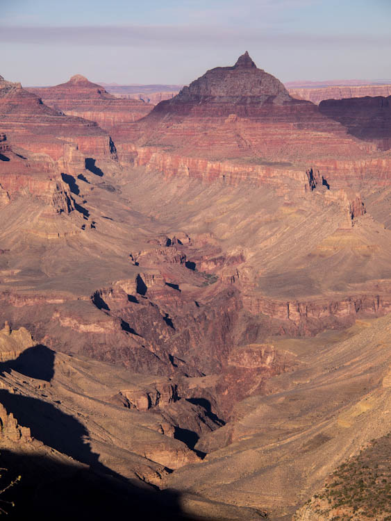
Wednesday, October 17, 2012
GRAND CANYON
After leaving Winslow we drove to Valle, about 30 miles from the Grand Canyon and decided to stay there and just have two shorter days at the Grand Canyon. Yesterday we did the eastern end of the South Rim and waited for the sunset at Deserts View. Today we did the rest of the South Rim, which is by shuttle only, so had to do the hop-on-hop off again. We did walk from one point to the next along the trek. The Grand Canyon is huge and very deep down into the valley floor with the Colorado river weaving through. At one stage we stood and watched some rafters going through the rapids (through the binoculars) which looked like a lot of fun.
We left the Canyon in the early afternoon and drove through to Kingman along some of Route 66. This old road was far preferable to the main highway. Along the way there were some signs which kept me amused. Each line was on a different sign. These are a couple I can remember.
If daisies are
your favourite flower
just keep pushing
the miles per hour.
CATTLE CROSSING
This means go slow
'cause that bull
Is some old cows beau.
Well the song does say 'You get your kicks on Route 66'.
 |
| Late afternoon - Colorado meandering through the canyon floor |
 |
| Sunset |
 |
| Ian at Powell's Point. Sean note the jacket - it's still going strong |
 |
| Variety of formations |
 |
| More formations and deep valleys |

CANYON de CHELLY, PAINTED DESERT AND PETRIFIED FOREST
Canyon de Chelly (d Shay) was really interesting with ruins dating from 13th century which we could see from various lookout points. The native Indians still live and farm in this canyon, although have to move out to higher ground in the wet season. This is in the Navajo Reservation, a huge area stretching into Utah, Arizona and Colorado.
The painted desert was really great, some wonderful colours and formations.
I was a bit disappointed with the Petrified Forest. Most of what we could see close-up were small pieces and I had to agree with Ian's cynicism that they looked like they were placed there for us tourists and photographers.
It's been a long day and we drove through to Winslow tonight which meant getting onto the motorway which was quite scary, only two lanes and huge semis that seemed to be racing each other, whilst at the same time we were driving into the late afternoon sun. The bonus was a lovely pink desert sky as we arrived to Winslow.
 |
| Part of Canyon de Chelly with Spider Rock. |
 |
| Ruins are just above the tree line and below the canyon wall. |
 |
| The painted desert - red and white |
 |
| More of the painted desert - colours varied from greys, purples and deep reds |
 |
| Petrified log sticking out of the wall |
 |
| Some of the many parts of petrified trees around the pathway. |
Sunday, October 14, 2012
ANTELOPE CANYON AND MONUMENT VALLEY
It's hard to believe that after the last two days overcast and wet weather we could wake up to such a magic day today. The sky was clear of cloud with a beautiful blue sky over the Arizona desert. We have spent the day in the Navajo Reservation Park. Our first stop was at the Antelope Canyon. I have seen photos of this canyon and never dreamt that I would have the opportunity to actually visit here. We had to go on a tour with a native guide (a lovely young woman) in a 4WD truck over a pretty rough bit of road to reach the canyon and we then walked through this amazing canyon which is almost like walking through a cave with just the tiniest bit of sunlight coming through. In the rainy season the canyon is flooded with water up to 3 or 4 metres high.
We drove on to Kayenta and after lunch went out to the Monument Valley. This is quite small in relation to many of the other parks we have been to. We tossed up as to whether we should do the 4WD tour or self drive and decided to drive through ourselves as we suspected that there would not be many stops for photos. We were right when we saw the many trucks going through and the only stops were at stalls selling wares. Ian says it was the worse 5 miles he has ever driven and I agree with him. It was really rugged and we were both pretty tense however were able to stop and look at our own time.
We have driven back to Kayenta tonight, found a motel and are both ready for an early night although for those following us on the map, it doesn't look like we have moved far at all, it has been a long tiring day.
 |
| Monument Valley. The worst road ever but great formations. |
 |
| We went through the canyon reasonably early and had some great colour coming through but it was very dark and I had to push the ISO up to 6400 to hand hold so the images are pretty grainy. |
Saturday, October 13, 2012
VERMILLION CLIFFS - GRAND CANYON TO PAGE
We are pleased we didn't drive on in the dark to Page last night as it gave us the opportunity to see the Vermilion Cliffs which stretch from much further north down through the Marble Canyon and then into the Grand Canyon.
It had rained heavily during the night however was reasonably clear when we set out and were very lucky to get through most of the day without the rain. We could see it across the flat landscape falling in strips where we had driven from.
We turned off at Lee's Ferry in the Marble Canyon and found a beautiful little spot on the Colorado River with very few people around and it was lovely just to be able to wander about. Ian went off on a track that took him to a bend in the river upstream where there were some old original buildings. This place has been a stopping place for many years for merchants and Mormons as they travelled to Utah to the 'Promise Land'. There were some great rock formations along the road as well as many of the canyon formations with lots of colours.
We finally made it to Page for lunch and decided to stay here for the night. Page evolved when Lake Powell was being built in the 1950s and now rely on tourism. There are over 20 motels and at least 14 churches of all denominations. We had to ask where the post office and supermarket were as the motels and churches dominated the main street as we drove in. We drove out to Lake Powell Visitors Centre and the rain finally caught up with us. We spent some time there reading how the Lake was built on the Colorado River (Glen Canyon Dam) and when the rain finished we drove out to see the Lake. Someone had said if you could image the Grand Canyon filled with water that would describe the Lake and that is what it is like. It is now a popular spot for boating and fishing with resort accommodation as well as camping.
 | ||||
The Vermilion Cliffs - this is part of the Navajo (native Indian) Reservation
|


GRAND CANYON - NORTH RIM
Well the weather god wasn’t kind to us today. We really can't complain though, I think it is only the third wet day we have had in 7 weeks. It was overcast when we left Kanab and as we
drove towards the North Rim of the Grand Canyon the skies became heavier. It was well and truly raining by the time we
arrived at the end of the North Rim road where we planned to start and work
backwards to the entrance. We sat in the
car for a while and then it seemed to ease off a bit so set off on the Bright
Angel Point walk. We went to the end however
it was far from bright and certainly not a good day for taking photos of wide
expanses of landscapes such as we could see in the mist. We had lunch at the Lodge, a place built in
the 1930s with a view over the Canyon from the restaurant. Whilst we were eating the rain seemed to ease
off and the sun broke through the clouds a few times.
 |
Not to be defeated we continued on to the Cape Royal Point
and we managed to do the walk without getting wet again. There were some great views and occasionally
the sun shone through the clouds. On the
way back to the entrance we stopped at some other vantage spots. We have been much longer today than expected
and decided to stay at Jacobs Lake instead of Page as planned and are in a
little cabin in the pine forest, the only accommodation at Jacobs Lake.
 |
| Very cloudy and overcast however still plenty of colour and shapes. |
Thursday, October 11, 2012
ZION
After spending most of yesterday down into the valleys, today we have walked through the valleys looking up at the gigantic monoliths of Zion Canyon. The whole landscape was completely different.
After going through the entrance to the park we drove on the most amazing road through tunnels cut through the rock (one is a little over a mile long) then down hairpin bends from the top to the bottom of the canyon. You can only drive as far as the visitors centre where you park and use shuttle buses to go to the various points. We stayed on till the end and did the first part of the Narrows walk. This is where the canyon becomes really narrow and you need to walk through the river bed to continue on. We then caught the bus back and hopped off and on and did other walks for the rest of the day. It has been a great day and the weather has warmed up and we worked up a bit of a sweat.
 |
| I don't often include people in my photos however these two ladies give a perspective to the size and height of the canyon wall. |
 |
| There is a great variety of colours in Zion as well as shapes and textures. |
 |
| Part of the Narrows walk. This innocent looking river, Virgin River, has carved out the canyons over millions of years and there are warning signs everywhere telling you to get back to the road quickly if it starts to rain as the river rises rapidly and is treacherously fast flowing. |
Wednesday, October 10, 2012
BRYCE CANYON
After leaving Brian Head we drove down to Bryce Canyon. Just before the National Park we came across Red Canyon which was exactly that, very red, with interesting shapes. Bryce Canyon is fantastic and we spent a good part of the day going to the various points, walking along the walkways and wishing we were fit enough to do some of the trails, although you would need lots more time if you were to do this. There were a number of cyclists pushing up and down the hills. We kept meeting up with one couple along the way and if they arrived somewhere before us would ask what kept us, that would have been on the downhill run.
After we left Bryce Canyon we had a very late lunch just outside the park and then started driving on towards Kanab which is where we are tonight in a very 'ordinary' motel. Along the way we diverted into the Coral Dunes Park. These were great dunes however, like all dunes, were covered in footprints and bike tracks. The colours were lovely pinks and in the late afternoon sun the shadows were purple.
 |
| One of the many different formations. Ian thought these looked like the Chinese Warriors. I imaged a Cathedral. |
 |
| Looking down into one of the canyons , the colours ranged from very soft pinks through to reds. |
 |
| Late Afternoon at Coral Dunes, Kanab |
Tuesday, October 9, 2012
REST DAY
When we woke this morning we decided to have a rest day so have been very lazy most of the day. We took a short drive to Cedar Breaks National Monument which is a lookout over looking a fantastic valley of formations. It is breathtaking and if this is all I get to see of the canyons I will be satisfied. We are up at around 10,000 feet and, although it is chilly, it is pleasant.


Looking left from lookout into the valley at Cedar Breaks

Looking right on to the canyon wall at Cedar Breaks
Monday, October 8, 2012
ROCK CANDY MOUNTAIN AND COTTONWOOD TREES
One of the good things about doing our own thing rather than being on a tour is to have time to stop and enjoy the scenery as well as chat to the locals which we have really done today.
The landscape was similar to yesterday although not as dramatic and colourful. There were still plenty of interesting formations and canyons along the way and it was easier to stop and spend time as the road was not as hairy as yesterday. We discovered that the haze all around is from the fires that have been in the Idaho area and are now blowing across to Utah and Wyoming. We were blaming some of the power stations that we have passed, particularly today and there is a lot of mining in the area.
We stopped at Marysvale at the only cafe in the vicinity which looked pretty ordinary however it was well past lunch time and we were ready for a break. This little place, Prospectors Cafe, turned out to be a gem. The owners, Rick and Donna were great to chat to. They moved from Las Vegas two years ago and needed work which was hard to find so they leased the cafe. Besides being a wealth of information about the area they were interesting. He had been a graphic artist and printer with his own business and she had been the 'mother' for the girls in a strip joint in LA. She had some great stories to tell. The food wasn't gourmet but filled the spot.
I headed this Candy Mountain and Cottonwood trees because we did drive past the real rock candy mountain that the song was written about and we have been in cottonwood country most of the day. The trees are a beautiful yellow through to orange as they change. These are mostly near water or damp areas, once you get up into the higher parts the birch are prolific.
We booked into a motel online last night and miscalculated the distance from Bryce Canyon so had a long drive out of our way to Brian Head which is where we are and have to retrace our steps back tomorrow to get to Bryce Canyon however the road is very scenic and not too hard to take, it just means that we will be later getting into the canyon than planned so will miss the early morning light.
 |
Cottonwood trees along a creek with grey formations in background 
Prospectors Cafe, not the most inviting to look at
|
Sunday, October 7, 2012
A LONG DAYS DRIVE
When we started out this morning from Jackson we drove through mile upon mile of flat sage brush and very else. At one point Ian said 'there's not even a tree to have a pee', not that he would have wanted to anyway as it was in the minuses again this morning. When we did get to a town the toilets were closed for the season. We've discovered this a lot as everything starts closing down on the 1st October for winter. We finished up having a hot chocolate in a bizarre cafe, it must have been there for 100 years however it did have toilets and then continued on. When we arrived at Rock Springs the landscape suddenly changed to the most amazing canyons and we drove through these for the rest of the trip to Price (Utah) which is where we are tonight. The road was very windy as we drove up and down mountains and along rims of these canyons. The colours are fantastic but unfortunately there weren't a lot of opportunities to stop for photos.


Along the road.
Saturday, October 6, 2012
We have spent the last two days driving through Yellowstone. Yesterday we took the geothermal area road stopping and looking at the many and various thermal sights, geysers, mud flows, hot pools through to Gardiner in Montana. It was 23 degrees F when we left Jackson Hole yesterday which we think is about minus 5C and didn't get past 5 degrees C all day. Each time we got out of the car to walk around the areas we really had to rug up. I love my gloves with the mitten fingers, it means I can take photos with gloves on even if they are a bit shaky with the shivers. We waited at Old Faithful to see the eruption which happens approximately every 75 minutes and once it starts spurts for about 3-4 minutes. It was well worth the wait in the cold and some soup and hot chocolate was very welcome when it was over
We made a vast change to the number of layers we put on this morning however it wasn't quite as cold. It probably started at minus 2 and warmed up this afternoon to around 10C.
We started off this morning at Mammoth Springs. When I came here 22 years ago these were huge with pools of steaming water flowing down from the top however they are much drier now and there is only one small area which is like I remember. We wonder if the many hotels and resorts that have sprung up since then are draining some of the underground water similar to what has happened in Pamakale in Turkey, we hope not but it does make you wonder.
From here we drove around the Canyon area which is fantastic and the Artist Point is just as I remember it, beautiful.
We are now back in Jackson and will start driving south tomorrow. There is plenty of driving to do and we have to keep moving on towards the Canyons which is where we want to spend some time.
 |
Steaming hot pools. Old Faithful 
Bubbling Mud Pools

Mammoth Hot Springs
|

Yellowstone Canyon and Falls from Artists Point
Thursday, October 4, 2012
TETON NATIONAL PARK
We drove from Afton to Jackson then to Jackson Hole this morning, called into the Information Centre and then booked into a motel for the night. We then went exploring the Teton National Park. These majestic mountains are worth spending the day around. The colours are not as prevalent as they were yesterday but still plenty, mainly yellow which we understand are cottonwoods. We walked along a couple of the lakes and as we were heading back to Jackson Hole saw our first bison by the side of the road.


The Tetons across Lake Jenny
Wednesday, October 3, 2012
UTAH

We had arranged for a hire-car to pick us up at 7.30 this morning and take us to the airport in Seattle.
As we drove out of the city the sun was just coming up and the light was just magic. I would have loved to have jumped out and taken some photos. We flew to Salt Lake City and picked up a rental car and after a few lefts instead of rights and wrong exits we finally stopped and asked for directions. The fellow we spoke with found it difficult to explain so suggested we follow him and he guided us onto the right road. What a wonderful thing for someone to do. All we could do was wave and toot as he pointed us on.
Once on the right road we just kept driving to Ogden and then started up the Ogden Canyon. This is where we first came into the magnificent colour. We finally stopped and had some lunch and then continued to climb up over the mountains. The colours changed from the multitudes of reds and oranges to the yellow birch. As we came down out of the high peaks we left the trees behind and discovered another palette of colour on the hillsides which ranged from creams through to rich reds and blacks and greys. As the sun set the hills changed to soft purples and pinks. We were hoping to make it to Jackson tonight however decided to stay at Afton about 70 miles before Jackson but had already driven 236 miles (approx 375 ks) and we were both feeling pretty tired and it was getting late.

The yellow birch
Subscribe to:
Comments (Atom)